System Overview
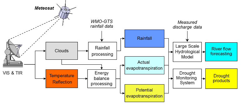
The system combines an innovative Meteosat based (operated and supplied by EUMETSAT) climatic data collection system (the Energy and Water Balance Monitoring System—EWBMS), with a large scale hydrological model (LSHM). Together these are able to provide spatially distributed, daily data on temperature, radiation, actual evapotranspiration, precipitation and river discharge at any location in the river basin. Therefore, besides river flow, the system also enables monitoring of drought and desertification. In addition, crop water requirements can be determined, supporting proper decision making and water allocation in agriculture.

Energy and Water Blance Monitoring System
Precipitation processing

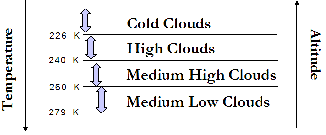
Precipitation is estimated using a combination of ground measured precipitation data and Meteosat satellite imagery. Using quarter hourly thermal infrared images, cloud levels are classified on the basis of their cloud top temperatures. This top temperature is related to the altitude of the cloud. Their presence is counted providing the cloud duration for different cloud height classes during each day. Ground measurements are obtained on a six-hourly basis through the WMO-GTS. These ground measurements are used to estimate rainfall from the cloud durations by means of 'local' multiple regression. The regression coefficients and the residual are determined for each rainfall station and its 11 nearest stations, which are then interpolated for each pixel. Hereafter, rainfall for each pixel is estimated with the regression equation, using the interpolated coefficients and residual.
Energy balance processing
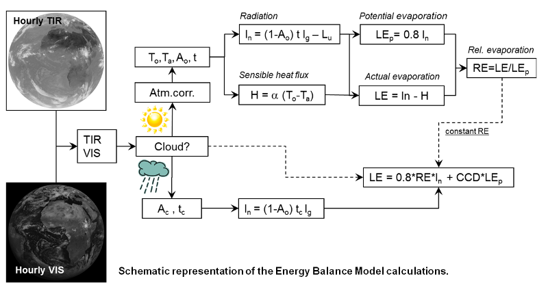
Actual evapotranspiration is derived through the earth surface energy balance. Quarter hourly thermal infrared and visual Meteosat data are pre-processed to noon and midnight composites. By means of calibration procedures the data are subsequently converted to planetary temperature and albedo. Atmospheric correction procedures are used to derive actual surface temperature and albedo. In addition the boundary layer air temperature (Ta ) is determined from the noon and midnight surface temperature using an analytic model of the daily temperature cycle.
The surface albedo, surface and air temperature are input to the calculation of the net radiation (In) and the sensible heat flux (H) at the earth surface. Once these are known, the latent energy flux (heat used for evaporating water) can easily be calculated and converted to actual evapotranspiration. When a pixel is cloudy, transmissivity is derived from its albedo and its long wave radiative fluxes are assumed to cancel. To estimate the distribution of net radiation between sensible and latent heat flux, the relative evapotranspiration of the last cloud free day is used. When cold clouds are observed this is corrected upwards on the basis of the cold cloud duration (CCD).

Large Scale Hydrological Model
Model overview
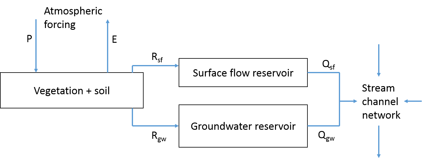
The large Scale Hydrological Model (LSHM) is specifically developed by UNESCO-IHE to work in conjunction with the Energy and Water Balance Monitoring System (EWBMS). The LSHM is a grid-based distributed rainfall-runoff model that is forced by the EWBMS rainfall and evaporation fluxes. Subsequently, the LSHM computes the flows in the land-phase of the hydrological cycle for a drainage basin defined as the area upstream of a target hydrological station.

The calculations effectively collect the water at all grid cells in the drainage basin and route the resulting discharge downstream towards the outlet. All grid cells are linked via the stream channel network that is connected according to the elevation differences between adjacent cells.
